History, politics, people of Oly WA

Author: Emmett O'Connell (Page 6 of 178)

Centralias Cannot Hold

A couple of notes before we get to the actual blog post:

  1. One of the first times I realized history wasn’t fixed came when I was a reporter at the Montesano Vidette. I was in my early 20s, still taking weekend classes at Evergreen. The Vidette was caught between eras—part hands-on production, part digital. We’d print our computer-written stories in column width, then cut and paste them onto pages before sending them off to the printer in Shelton. Just a few feet from our front door sat a century of bound newspaper editions. Every week, a handful of historians, history buffs, and family genealogists came by with spiral-bound notebooks and pencils to take notes from those oversized volumes.

One afternoon, an older woman arrived with an overstuffed backpack. She’d taken the bus up from Lewis County, connecting through Olympia. I was killing time before heading to the Elma City Council meeting when I noticed she had several volumes open, covering 1918 through 1923. She was searching for traces of a relative involved in the Centralia Massacre, back when Wobblies clashed with the American Legion.

What stuck with me most, though, was seeing her again later that night in Elma. Before the council meeting began, she approached the city clerk to ask if she could examine city records. She was catching the last bus out of Grays Harbor but had seen the city hall lights on and decided to stop. The clerk said no, and the police chief—who always attended council meetings, handed her a coupon for a hotel room and the bus out in the morning.

Here was someone, retired, without the money to drive, so convinced the official story of American Legionnaires bravely fending off Wobbly attackers was wrong that she hiked and bused her way to dig through the record. The Centralia Massacre is still debated today. If you don’t know the ins and outs, you can still follow along here. You don’t need to be a historian. But the story is fascinating. And, much like the legend of Marcus Whitman, the “official” tale is a heroic cover over a much deeper, messier truth about our region.

  1. For obvious reasons, I’ve also been thinking about the opening stanza of Yeats’ The Second Coming:

Turning and turning in the widening gyre
The falcon cannot hear the falconer;
Things fall apart; the centre cannot hold;
Mere anarchy is loosed upon the world,
The blood-dimmed tide is loosed, and everywhere
The ceremony of innocence is drowned;
The best lack all conviction, while the worst
Are full of passionate intensity.

There are endless reflections to draw from this poem, most circling back to the idea that history doesn’t repeat, but it does rhyme. Yeats had just witnessed the devastation of the Great War and the collapse of centuries of British rule in Ireland. An old order (unjust though it was) was giving way to violent disorder. His imagery: paths spinning away from the center, blood in the water, a beast slouching toward Bethlehem, captures both dread and inevitability. History was turning, but not toward salvation.

Centralias

There are a lot of Centralias in the United States. Twelve, as best I can tell. Fargo, North Dakota, used to be a Centralia, but changed its name. If you trace five of these Centralias (Missouri, Oklahoma, Washington, Illinois, and Pennsylvania), you can run a bloody finger across American history since the Civil War.

1864: Centralia, Missouri

Not at the forefront of the campaigns in Virginia or the Mississippi Delta, Centralia, Missouri, was caught in the deeper, revenge-fueled violence that marked the darker history of the Civil War. On September 27, 1864, Confederate guerrillas led by William “Bloody Bill” Anderson (joined by a young Jesse James) launched the Centralia Massacre. They boarded a train, separated 24 Union soldiers on leave, and executed them. It did not stop there. The guerrillas looted the town, torched the train, and set fire to the depot.

The Missouri front of the war was an irregular backwater, but it carried the legacy of Bleeding Kansas, and its violence was no less savage.

Later that same day, a Union force of 146 inexperienced mounted infantry was sent to intercept Anderson’s men. The clash became the Battle of Centralia. But if not for the earlier massacre, this too might have been called a massacre. The Union troops were severely outmatched and overrun. Anderson’s fighters killed 123 soldiers, nearly annihilating the detachment. By the end of the day, 147 Union casualties had marked Centralia as a site of wartime horror. Observers at the time called it an “inhuman slaughter” and one of the “chief barbarisms of the war.”

The massacre was not an isolated event but part of the escalating cycle of frontier violence that began with Bleeding Kansas in the 1850s. Confederate guerrillas sought revenge against federal forces who had occupied the Missouri-Kansas borderlands. Union responses were just as brutal: Brigadier General Clinton B. Fisk suggested “depopulation and devastation” in retribution, citing earlier expulsions of border residents under General Ewing’s orders. The violence was reciprocal, entrenched, and unrelenting.

1901: Centralia, Oklahoma

After the Civil War came emancipation, Reconstruction, and then its collapse. Jim Crow laws and sundown towns spread across the nation, systems of racial control maintained by violence, and sometimes resisted by violence.

That resistance flared in Centralia, Oklahoma, in October 1901.

White residents tried to drive Black families out of town one night. A group of white men attacked the home of a Black resident, Whitmitre, firing into the roof and forcing his family to flee into the dark.

In response, Black townspeople armed themselves. Shots rang out along the streets, and white residents barricaded themselves inside their homes. In the chaos, a white woman was shot. The Black residents’ message was clear: they would not be driven out. Federal authorities later arrived and suppressed the uprising, arresting one Black man for shooting the woman.

Centralia was not the only place where white people forcibly removed residents based on race. But it is one of the few where people of color stood up and fought back.

1919: Centralia, Washington

This is the one most people around here know.

On November 11, 1919, a parade to celebrate the end of World War I, a year before, erupted into bloodshed. The Centralia Massacre (sometimes called the Centralia Conspiracy, Riot, or Tragedy) pitted the American Legion against the Industrial Workers of the World (IWW, or “Wobblies”).

The massacre grew out of long-standing tensions between the Wobblies and a coalition of local business owners, the American Legion, and government officials. The IWW pushed for all workers to unite as a class, take control of production, and challenge the capitalist system. They often used “direct action” tactics like strikes and public speeches to make their point. Their anti-war stance during World War I only made matters worse. Many locals saw them as unpatriotic, even traitorous.

The 1919 killings were an escalation of years of attacks by the anti-IWW coalition. In 1914, IWW members looking for food were marched out of town. In 1917, they were evicted from their union hall. And in 1918, a group of businessmen raided the hall during a Red Cross parade, beating members and dumping them outside town.

When the shooting ended, six were dead: four Legionnaires, one Wobbly, and a deputy sheriff. The Wobbly, Wesley Everest, was captured, jailed, and later lynched by a vigilante mob. Some IWW members were convicted in the aftermath, but no one was charged in Everest’s killing or for the assault on the union hall.

1947: Centralia, Illinois

The bosses had been warned, but the mine blew up anyway.

On March 25, 1947, an explosion tore through Centralia Mine Number 5. Coal dust ignited, killing 111 miners.

The hazards were known long before. State and federal inspectors, union officials, and safety officers had warned of the coal dust buildup and unsafe blasting practices. Management ignored the warnings. At one point, they even admitted to unsafe practices. Still, nothing changed. The result was a catastrophe.

Whenever you hear about regulation, safety rules, and the economy, you should think back to Centralia, Illinois. This was a time when labor unions wielded more power than today, yet workplace safety rules were ignored enough that killing 111 men barely registered beyond becoming the fifth-worst workplace catastrophe since 1940.

1962: Centralia, Pennsylvania

Rather than destroying 100 miners in an instant, this Centralia has been erased slowly, in smoke and fire.

At least, because authorities could foresee the danger, they eventually stepped in, after allowing the even bigger wrong to happen.

Since 1962, an underground coal seam fire has burned beneath Centralia, Pennsylvania. Most believe it started when a landfill fire spread into abandoned mines. The consequences have been terrifying.

In 1979, a gas station owner discovered his underground fuel tanks had reached 172°F. In 1981, a 12-year-old boy fell into a 150-foot sinkhole in his backyard—saved only by clutching a tree root. Carbon monoxide seeped through the ground.

The fire led to a slow evacuation. In 1983, Congress gave $42 million for relocation. More than 500 buildings were demolished. In 1992, the state seized remaining properties through eminent domain. The town lost its ZIP code in 2002. By 2020, only five residents remained, having won the right to stay for life. Today, Centralia is little more than cracked roads, weeds, and warning signs of fire and poison gas.

Centralias

The center did not hold in Missouri, where border wars became slaughter in the Civil War. It did not hold in Oklahoma, where white supremacy cracked and Black resistance burned. It did not hold in Illinois, where profit outweighed miners’ lives. It did not hold in Pennsylvania, where the earth itself betrayed its settlers, burning from below.

And so it goes: America is a lone Douglas fir in a wind storm, fragile and furious. Stability is never given; it is enforced, at someone else’s expense, until it snaps.

Order, a center, is forced by guerrillas, mobs, bosses, and bureaucrats. All tools of power that maintain control until they go too far, and tragedy ensues.

The Centralias are not exceptions. You could grab more city names out of a bag and find a host of similar sundown town violence, industrial accidents, and labor wars. Centralias are warnings.

Things fall apart. The Centralias cannot hold. And the little anarchies are loosed.

But in the end, most of these Centralias still exist. Missouri is still on the map. Washington and Illinois are scarred by history, but still there. Even the Centralia that was wiped off the face of Pennsylvania was not erased by indifference but met, however imperfectly, with responsibility and relocation. Yeats’ Ireland, torn by violence, moved on, even now edging toward reunification. And Europe, as it leans towards continental war again, has also seen long stretches of peace and reunification. History is not only a blood-dimmed tide. It carries moments of rebuilding, of reconciliation, of quiet endurance. The fire does not burn forever, and the center, however fragile, can be rebuilt.

The City of Puget and how we build cities

There’s something about a neighboring city moving into nearby unincorporated neighborhoods that always gets people excited and wanting a city of their own. At least around here.

That’s exactly what happened in the 1960s when Lacey became a city.

The Birth of Lacey: A Rivalry with Olympia

Lacey’s path to cityhood was shaped by a rivalry with Olympia over annexation and control of fast-growing suburbs.

After World War II, Lacey shifted from farmland to a booming suburb, helped by projects like South Sound Mall. By the early 1960s, Olympia began pushing east, annexing land along Martin Way and Pacific Avenue up to Lilly Road. This sparked a “border war” as Lacey moved to incorporate and protect its own boundaries.

Lacey’s first incorporation vote in 1964 failed, but a second vote in November 1966 narrowly passed by about 200 votes. Almost immediately, conflict reignited. Residents of Lacey’s western “Olympia fringe area,” who had opposed incorporation, voted to leave and join Olympia in early 1967. Lacey sued to block the move, but courts upheld Olympia’s annexation under an old 1890 law (later changed in 1969).

That same year, voters in both cities considered merging into one. Supporters said it would cut costs, improve planning, and solve Lacey’s sewage problems by tapping Olympia’s system. The proposal failed, badly in Lacey, where residents strongly opposed merging.

The 1980s: Lacey Looks North to Puget

In the ’70s and ’80s, Lacey tried to annex eastward but hit resistance from established neighborhoods like Tanglewilde and Thompson Place. Much like Lacey in the ’60s, these neighborhoods didn’t want to join a bigger city, or form their own. They already had regional fire services, and Tanglewilde even formed its own park district, building the county’s only public pool.

So Lacey looked north, toward undeveloped land between those neighborhoods and Hawks Prairie.

During the 1980s, Lacey took an aggressive annexation strategy, focusing on big undeveloped areas with huge growth potential, like Hawks Prairie. This land promised billions in development and tens of thousands of jobs over two decades. Lacey wanted to bring in sewer, water, and other urban services while avoiding the political headaches of older neighborhoods.

At the same time, Lacey played defense. It annexed strategically to stop the proposed City of Puget, an effort by rural residents to block Lacey’s expansion. Just like Lacey vs. Olympia before it, the Lacey vs. Puget City battle took on the same tenor of trying to keep the neighboring big brother from taking over.

The proposed City of Puget was named after an unrealized metropolis on Johnson Point. Puget City was platted in 1870 (and promptly un-platted three years later) as a possible terminus for the railroad. There are actually a handful of homes that sit on “Puget City” parcels in the area, but obviously, the rail road city was never built. As Lacey started their march to the inland sea in the 1980s, rural residents staked their own claim and petitioned the boundary review board for the creation of the 3,000 person City of Puget.

The new city idea died after the Boundary Review Board voted it down 3-2. The board leaned on a rift between residents of the rural areas and developers and residents of larger planned neighborhoods that wanted Lacey’s services.

One big difference between the 1960s and the 1980s? The Boundary Review Board. Created in 1967, these boards added consistency to city formations and annexations. You can’t rewrite history with “what ifs,” but it’s interesting to imagine what Lacey’s future would’ve looked like if it had been blocked like Puget.

Ultimately, Lacey annexed thousands of acres, leapfrogging older neighborhoods to build new subdivisions and warehouses. Those skipped-over neighborhoods fought off annexation attempts for decades, and now, in 2025, Lacey is looking back at them again.

But first: How Cities Grow

This brings me back to my favorite academic paper I’ve read this year, The Neutral Criteria Myth. In a discussion about legislative redistricting, it points out that histories like Lacey’s show how city boundaries might look like simple lines on a map, but they are anything but neutral. These boundaries have long been used to shape communities, deciding who holds power and who gets resources.

Historically, these lines were often drawn with racial and economic bias. Redlining is a clear example, where minority neighborhoods were confined to underfunded areas. At the same time, wealthy, mostly white suburbs drew boundaries to separate themselves from urban centers, creating large gaps in wealth, schools, and public services. The truth is, there is no such thing as a neutral city boundary. These lines have always been about more than geography, they shape opportunity and segregation in ways that last for generations.

City lines affect property values, school funding, and even political representation. Local gerrymandering (redrawing district maps to favor one group) can tilt power and weaken others’ votes. Annexation decisions also play a role: cities often target areas that bring in tax revenue while avoiding neighborhoods that may be costly to serve.

This is exactly the situation Lacey faces today. Decades after growth management laws placed the old Tanglewilde and Thompson Place neighborhoods in Lacey’s Urban Growth Area, the city is now looking back at the areas it skipped over. They have studied what annexing these unincorporated neighborhoods would mean. Their new financial analysis offers a clear answer: annexation would likely cost more than it brings in, at least in the near term. The study examined three growth scenarios, and in every case, the city would face a financial hit. Even after 20 years, the costs of police, fire, and utilities outweigh the tax revenue these areas would generate.

So, annexations have biases towards the needs of the current city residents. Systems like boundary review boards can help short-circuit these biases and bring more rational decision-making, but I think there is a broader model.

One idea I’ve been thinking about is to take city boundary decisions out of the hands of cities themselves. Currently, cities often push annexations for more tax revenue or strategic growth. But what if an independent board handled it instead, similar to the commissions used for legislative redistricting?

This board wouldn’t have a stake in politics or money. Its sole goal would be ensuring that services, water, sewer, police, fire, are delivered efficiently. It would focus on creating logical city limits that make sense for residents and future growth, not just for city budgets. The concept is simple: draw boundaries based on what works best for communities.

In many places, higher levels of government already step in to manage city boundaries rather than leaving decisions to individual cities. They do this because it can bring major public benefits, better planning, stronger services, and less wasteful competition between municipalities. Sometimes this happens through state or provincial laws. Other times, independent boards (like Boundary Review Commissions in the U.S. or Municipal Demarcation Boards in South Africa) take the lead. Their role is to look at the bigger picture: how to manage growth, avoid urban sprawl, and ensure communities are connected logically.

Why does this matter? When cities compete over territory for tax dollars, services suffer and local governments end up fighting instead of cooperating. Provincial or national intervention can fix that. In Canada, provinces sometimes merge or reorganize municipalities so services align and resources are shared fairly. In South Africa, national boards bring diverse communities together under one system, promoting equity and social cohesion.

The goal is simple: instead of a patchwork of self-interested annexations, create a more thoughtful, planned approach to city boundaries, one that serves people.

Digging Deeper Into the August Primary Results

After posting my first results map for the August Primary and releasing a discussion episode on The Olympia Standard, I wanted to take a closer look at a few things that stood out to me.

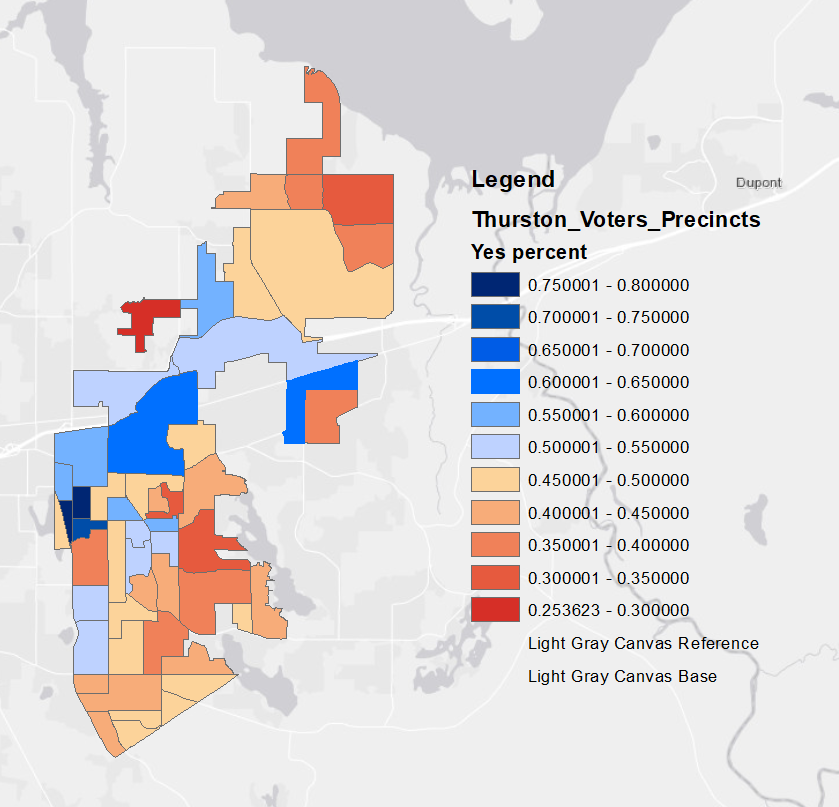
1. Lacey’s Parks Proposition: Where Did It Win?

I don’t talk about Lacey all that often, but the failure of the parks proposition caught my attention. The geography of support was interesting.

  • Panorama City, the retirement community that once dominated city politics, was very pro-parks.
  • Precincts around Wonderwood Park were also supportive, which makes sense—it’s a walkable neighborhood park that feels embedded in the community.
  • But near Rainier Vista Park, support wasn’t as strong. That also tracks. I can see how a park like that could feel like a nuisance to neighbors. My most vivid experience there? Having a neighbor yell at me for driving around the block looking for parking.
  • And then there’s the weird belt of pro-park precincts hugging I-5. These are newer neighborhoods. Maybe those residents are hoping for more parks to be built, like the Greg Cuoio Community Park, which is still undeveloped.

2. Simplifying the Results Maps – The “Left Lane” Candidates

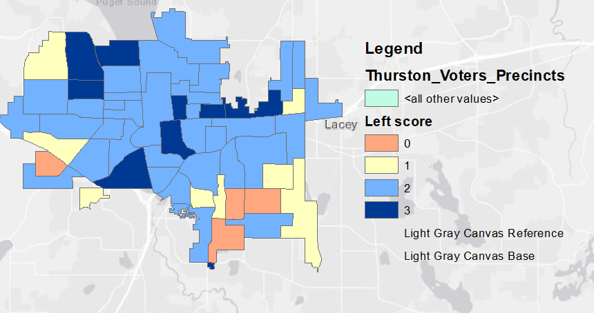
While looking back at the maps I made earlier, I realized I could simplify things by categorizing results based on how many “left lane” candidates won in each precinct. These were the easiest to group together, Vanderpool, Gilman, and Geiger.

When you do that, some interesting patterns jump out:

  • The Southeast bubble is still very clear.
  • You can see far Westside outliers too that consistently lean conservative.
  • But Olympia 31, near LBA Park and deep inside the SE, voted for two left-side candidates. That suggests the SE line might now run along Henderson Road, rather than everything south of I-5. If so, that could mean the older neighborhoods west of the high school are shifting politically.
  • And then there’s Olympia 45 (around Lilly Road and Martin Way). It only voted for one left-side candidate. Why? If anyone has theories, I’d love to hear them.

3. Krag Unsoeld vs. the Countywide Map

On this week’s Olympia Standard podcast, Rob Richards explained why he doesn’t think Krag Unsoeld is likely to win in November, even though he had a strong August showing. The reasoning: Port Commission races are district-based in the primary but countywide in the general. Krag didn’t dominate enough in his left-leaning district to make up for the more centrist countywide electorate.

That’s a theory, but does the math back it up?

I went back to the 2023 Port races and built a precinct-by-precinct extrapolation, comparing left-leaning general election results with Krag’s 2025 in-district primary numbers. Even though left-side candidates swept the table in 2023, Krag’s numbers don’t project well.

By my estimate, he’d lose the general by about 8,000 votes, 42,000 to 34,000.

We lost our neighborhoods, we lost our unions

Ironically, it was called the People’s Store.

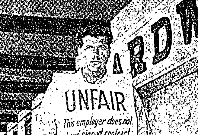
People’s opened in spring 1966 to a large gala, just as the South Sound Center in what is now Lacey was welcoming its first tenants. Outside the Ernst store next door stood Dale Parsons, ruining the festive mood. He was a lone union picketer. He carried a sign pointing out that Ernst was non-union. The twist? Parsons wasn’t a union member himself, he had been hired by the Olympia Retail Union to advertise that Ernst hadn’t signed a contract.

The 1960s marked a turning point for Olympia’s retail unions, which had been part of the city’s commercial fabric since 1903. Historic places like The Spar, a gathering spot for workers since 1935, still stand as reminders of this legacy. But like many cities across America, Olympia’s labor movement has faced a long, slow squeeze driven by suburban sprawl. Since the end of World War II, outward growth has reshaped communities, economies, and, critically, unions.

By the late 1960s, the impact of suburbanization was already clear. The lone protester outside the new mall was a visual symbol of a shifting retail landscape. As businesses moved from downtown into suburban shopping centers, the local clerks’ union faced new challenges. A more dispersed workforce made organizing harder, eroding both membership and bargaining power.

The challenge became even more obvious two years later, during a 1968 retail strike in neighboring Grays Harbor. The new highway from Elma to West Olympia gave shoppers a simple way to bypass picket lines, by driving to Thurston County to do their shopping. That convenience undermined the strike and foreshadowed how suburbanization would continue to weaken union efforts.

The suburban boom wasn’t just about housing. It brought a new model of shopping. Downtown business districts gave way to malls in Lacey and, later, on Olympia’s Westside. Big-box stores like Kmart, Target, and Walmart (with their sprawling footprints, parking lots, and all-in-one convenience) pulled shoppers further from city centers and unionized workplaces.

For employers, this shift was no accident. Moving jobs out of dense urban cores allowed companies to tap into cheaper, less unionized labor markets. This geographic dispersion deliberately weakened what one scholar called the “natural solidarities of work and neighborhood,” long the foundation of urban unions. Union leaders themselves have noted that big-box development often displaces union jobs, and that union density falls the farther you get from the city’s core.

The obstacles weren’t only geographic; they were political. While private-sector union membership collapsed after the 1970s, automation and globalization weren’t the main drivers. The bigger factor was employer resistance. The Taft-Hartley Act of 1947 had already weakened unions, and in the decades that followed, employers increasingly fought organizing efforts with tactics like threats of store closures and mandatory “captive audience” meetings. Courts often sided with management, making it harder for workers to organize and sustain unions.

Despite these national headwinds, Olympia’s main retail clerks’ union (now UFCW Local 367) has survived and adapted. Founded in 1934 as Retail Clerks Local 367, it now represents thousands of workers across Thurston, Pierce, and Grays Harbor counties.

A major milestone came in 1979, when the Retail Clerks International Union merged with the Amalgamated Meat Cutters to form the United Food and Commercial Workers (UFCW) International Union. While UFCW 367 remained a distinct local, it has often joined with neighboring unions for major contract negotiations. In 2013, for example, coordinated bargaining across locals narrowly averted a grocery strike.

As cars reshaped our communities, we lost walkable, “people-oriented” spaces. At the same time, we lost people-oriented institutions: retail unions, which all but disappeared from the suburban landscape. On a recent episode of The Olympia Standard podcast, it seems very on point that we discussed how the drive-through model at Starbucks can feel dehumanizing and why unions remain essential in retail work.

Today, we’re rethinking our communities, emphasizing denser neighborhoods where services are closer to the people who need them. But as we rebuild our physical landscape, we also need to rebuild our labor landscape. Union density still matters. Wherever people work, they deserve a voice on the job.

Five initial lessons from the August 2025 Primary

The Friday after Election Day is a pretty big day for me. That’s when the first round of precinct-level data is released. Using that data, I dive into the maps to see if there are any lessons to be learned.

Until I get to a couple of Olympia School District (OSD) races, I colored the maps in this post all the same way: for any candidate, blue indicates where they did better, and red shows where they did worse.

  1. Paul Berendt is probably fine.

I don’t expect his campaign to ease up, but the big risk he faced in how this election was set up didn’t materialize. Berendt definitely isn’t a right-leaning candidate in any broader sense beyond being an Olympian, but running against a DSA-endorsed progressive puts him on the right side of the scale here. Also, in my part of town, his signs have consistently been paired with candidates who would be classified as right-leaning, no matter how you slice it. The Maria Flores vs. Taluana Reed race shows how traditional left candidates, when paired against far-left candidates, can produce a map that highlights a base of support in more traditionally right-leaning areas of Olympia.

The risk is that the neighborhoods that show up in August don’t necessarily match those that turn out in November. A strong showing in August, generally in SE Olympia, can box a candidate in come November when other neighborhoods show up. So, what Berendt needed was support from a diverse range of neighborhoods, which, as we can see below, he achieved.

  1. Winning maps look similar.

Robert Vanderpool had a winning map very similar to Berendt’s, though arguably he was running in the same lane as Berendt’s opponent, Caleb Geiger. Is this the advantage of being on the council right now? There’s a slight west-side shift in Vanderpool’s map, likely reflecting the different lanes, but I want to chalk this up to how people in Olympia vote, which isn’t always the laundry list of issues campaigns highlight.

  1. Wendy Carlson’s long road to November.

The key to winning from the right or moderate side is to dominate the areas where you’ll be safe in November (SE Olympia and some far west-side precincts) and be competitive everywhere else. This was not the case for Carlson (or Justin Stang, for that matter). I’ve included Carlson’s map here to illustrate. While she did produce lighter reds throughout SE Olympia, these are places she would have wanted to lock down now so she could expand her support in November.

To be completely fair to Carlson, mapping the winning and losing precincts in a multi-candidate primary using this system isn’t super helpful if the candidate wasn’t in first. What I should do is just map where she got a plurality of the vote and go from there.

  1. Winning maps look the same Part 2: Renee Fullerton dominated, only losing in Rhyan Smith’s SE Olympia stronghold.

What was actually surprising in these races was that Jeremy Ruse also failed to advance out of the primary, but the map doesn’t help clarify why. Fullerton’s map is a classic August winner, taking nearly everything except SE Olympia—ironically where her district is centered. For some, this could be an argument in favor of district elections in school boards.

  1. The interesting race now shifts to the Olympia School District’s west-side contest, where Emily Leddige and Gil Lamont bested right-leaning candidate Ruse.

I did something different with their maps, shading for overall support instead of simply above or below 50 percent. The basic story is that Leddige seems to have a west-side shift compared to Lamont. I’m not sure what this means for electoral strategy, but Lamont is slightly ahead, so he might be better positioned to pick up whatever votes remain from Ruse.

Here is Leddige’s map:

And Lamont’s:

There are a few more things I want to do with this election’s precinct data. In addition to remapping Carlson’s race, I’m going to stretch out to Lacey and look at their Prop 1 parks vote that failed, and extrapolate the port data to see what I find there.

They Used the Profits to Replace Us

In 1986, thousands of timber workers along the Washington coast went on strike. In the middle of the walkout, seven workers (occasionally joined by their union brothers and families) walked more than a hundred miles to Olympia.

They marched to demand that Governor Booth Gardner, scion of the very timber corporation they were striking against, intervene on their behalf.

The “Save Our Communities March” culminated in a noon rally on the Capitol Campus on Friday, July 25, 1986, attended by roughly 1,500 striking Weyerhaeuser workers and their supporters.

Gardner didn’t intervene. And the workers eventually had to surrender. During a short speech at the rally, the governor was booed and heckled as he urged workers to accept change in the industry if they wanted it to survive.

Gardner talked in the same language as timber company bosses: that competition from the American Sound and Canadian mills made the heavily union communities in the Pacific Northwest hard to pay for.

Weyerhaeuser was demanding a $6 per hour average wage and benefit concession. In return, the company offered a profit-sharing plan. They promised workers a share of the profits, but only if their specific mill performed well. The problem with that was that you needed a job to share in the profits.

Union members suspected the company was trying to claw back hard-won gains, especially given that some mills had remained profitable. A week before the rally, the strike had spread to 6,200 Weyerhaeuser workers across the Northwest.

But, the march on Olympia happened against a backdrop of unraveling solidarity, as the company began reopening mills using salaried employees and union workers who crossed picket lines. This led to scattered confrontations: rock-throwing, damaged vehicles, but the incidents were isolated.

So by that Friday, 1,000 had crossed the line, and 1,500 were shouting at the governor.

And three days later, 11 Weyerhaeuser plants were back in operation with a combined workforce of 1,600 union and non-union employees. The unions lost.

They had initially sought a wage increase and better benefits. But when the 52-day strike ended on August 18, 1986 when union members ratified a new contract that included both wage and benefit reductions and a profit-sharing plan to partially offset the losses.

Looming over the entire strike was Weyerhaeuser’s ongoing push to replace human labor with automation. In the seven years leading up to the strike, timber jobs in Oregon dropped 15 percent, even though lumber output increased. The workers knew what was coming. The spotted owl hadn’t even entered the conversation yet. It was always automation.

The workers in Aberdeen and Raymond went back to smaller paychecks and to jobs that were increasingly being done by machines. But at least they had profit-sharing.

Just weeks before the strike, a millworker named Ivan Breider told the Seattle P-I exactly what was going on: “If they got too much profit, they’ll put in new machines… or robots to do more of the jobs. That’s what they’re going to use it for—to eliminate jobs with. The men will never see it.”

He was right.

Ten years after the strike, Weyerhaeuser had cut 10,000 jobs worldwide, 1,400 in Washington alone, without cutting output.

And eight years after the strike, the Northwest Forest Plan was adopted, changing the mix of wood supply to protect endangered species like the spotted owl. But while automation had been erasing jobs steadily for years and unions had slowly capitulated, the dominant narrative became all about the owl.

Automation wasn’t unique to Weyerhaeuser. It was reshaping the entire wood products industry. Labor economists summed it up clearly: “Automation has affected us all.”

But we’ve forgotten the 1986 strike, the “March to Save Our Communities,” and the workers who saw corporate greed and automation as the real threat. We’ve replaced it with a story about a battle between environmentalists and loggers.

That shift in narrative was missed by KUOW in a recent piece about tariffs and the possibility of re-opening Northwest forests for harvest:

“So, why has the timber industry here declined so much?”

Mill manager Aaron Poquette had some answers: increased difficulty harvesting from public lands, the timber wars of the 1980s and ’90s, and wildlife protections like the spotted owl.

“The harvest volumes that come off the national forest right in our backyard are nowhere near what they were in the ’80s and early ’90s,” Poquette said. “We have this huge timber base… but we’re just not taking the harvest.”

He also cited rising labor costs, industry consolidation, and changes in forestland ownership.

What’s missing? The jobs lost to automation.

The story almost gets there:

“Barnes’ career path illustrates how, over time, mill jobs are becoming more highly skilled and valuable. Now, with AI technologies entering the mill, doing things like visually grading the quality of each board, that transition continues.”

But even then, it pivots back to supply.

Why does it matter whether the problem is supply or automation? The slow disappearance of human labor in the timber industry is part of a much larger story. The story of people vs. machines. John Henry vs. the steam drill.

This was the last-gasp strike before automation eliminated jobs, and we blamed it on an owl.

But it’s not just a story about timber workers. It’s also a story about software engineers and artificial intelligence. Microsoft is laying off thousands while leaning into AI. There’s a bone-deep fear that these high-paid, high-skill jobs will go the way of the timber mill, gone in a generation.

A few years after Zoom school hit and laptops became required, kids are now burning their school-issued Chromebooks. And I know Zoom school was the right call at the time. But something is unnerving about requiring a computer to attend school, even as we rip phones from students’ hands in the name of technophobia.

This is also a lesson about our humanity. No matter how far we go, we are still us.

In the same way, we now call for walkable neighborhoods because we’ve realized that building around cars took something from us.

Technology isn’t the enemy. Humanity is the friend.

The Luddites didn’t smash looms because they hated machines; they did it because they hated the bosses who used those machines to devalue their labor. They weren’t anti-tech; they were pro-dignity. The looms were cheaper than people, and the bosses did the math.

The same math has come for loggers. It’s coming for coders.

In a sweeping essay on AI policy, Matt Stoller points to this exact dynamic.

There is in fact a common habit of powerful monopolists choosing to point out a supposedly neutral larger-than-life force, such as ‘technology’ or ‘the future’ or ‘disruption’ or ‘globalization’ to argue that they are not responsible for the anti-social policies enabling their market power. For instance, in 2013, there were a lot of complaints about Amazon avoiding sales taxes and engaging in predatory behavior around book pricing. How did Jeff Bezos answer this charge? “Amazon is not happening to book selling,” he said, “the future is happening to book selling.” I see a lot of similarities between that political language and the AI discourse.

That language of inevitability, of shrugging responsibility that timber companies used against unions as competition from the south, from Canada, from overseas mills, is the same language we now hear in AI discourse.

And it’s why the marchers who reached Olympia 39 years ago still matter. They stood on the Capitol steps shouting for union support, even as scabs crossed picket lines and machines took their jobs. They came to save their communities.

But you can’t drive through Aberdeen today and say their community was saved.

Wendell Berry, in his essay “Conserving Forest Communities,” lays it out in practical terms. Two draft loggers, using horses and old-style skidders, logged a section of forest over two months. A single man in a modern tractor could have done it in a day. Both methods were profitable. But only one employed more people, caused less environmental damage, and strengthened the community.

The timber company and the manufacturer would answer on the basis of purely economic efficiency: the need to produce the greatest volume… in the shortest time. The community, on the contrary and just as much as a matter of self-interest might reasonably prefer the way of working that employed the most people for the longest time and did the least damage to the forest and the soil… From the point of view of the community, it is not an improvement when the number of employed workers is reduced by the introduction of labor-saving machinery.

Stoller points to an essay by Bharat Ramamurti, Zoe Jacobs, and Diego Haro, who argue that our future lies in the power of those people on the Capitol steps in 1986.

AI shouldn’t mean handing over our livelihoods to algorithms or letting billion-dollar corporations decide, unchecked, whose jobs survive. They’ve already been doing that for decades.

We need policies that give workers a voice, not after the layoffs, but before a single AI system is installed. From stronger unions to new models of industry-wide bargaining, we must make sure that the people who do the work get to help decide how the work is done.

Empowering workers to shape the future isn’t just fair. It’s the only way this leap forward becomes something that serves the many, not the few.

Revisiting Magnet Theory, Migration, and the Myths We Tell Ourselves

Over the last two weeks, I’ve written about overlapping ideas:

Two weeks ago, I looked at the demographics of Olympia, Thurston County, and Washington State, and the impact of new migrants on the size and shape of our communities.

Then last week, I explored a concept known as *magnet theory,” and how it shows up in local conversations. A key example was a local candidate who claimed to have found a smoking gun: proof that the City of Olympia was using magnet theory to pad its budget. That claim turned out to be false, but it got me thinking about how we talk about new residents in our community.

First off, magnet theory seems to be having a revival as we head deeper into this municipal election year.

The Spokane Business Association (SBA) released a survey claiming that over 50% of Spokane’s unhoused population moved there after becoming homeless.

City data and national research contradict the SBA’s findings. Spokane’s 2024 Point-in-Time Count and longitudinal studies show that about 80% of unhoused people are from Spokane County.

It turns out the SBA’s poll was the kind of study that finds exactly what it sets out to prove. Experts argue it was methodologically flawed, misleading, and politically motivated. Designed by former Trump homelessness adviser Robert Marbut, the survey used biased questions, a small sample size, and questionable methods, like having volunteers identify homeless people by sight.

Critics, including local service providers and city officials, say the report dehumanizes unhoused people and promotes a divisive “us vs. them” narrative. Even some who agree with Marbut’s policy preferences dispute the report’s central claim.

Here in Thurston County, we’ve seen similar rhetoric. Former County Commissioner Gary Edwards was well-known for opposing funding for homelessness services unless it was tied to where someone came from.

But the data tell a different story. In our most recent Point-in-Time Count, only 8% of unhoused people reported coming from out of state. Nearly 80% said they became homeless in Thurston County or a neighboring county.

That stands in stark contrast to the broader population. According to the most recent American Community Survey, 42% of Thurston County residents were born in another state.

And that doesn’t even capture the regular churn of migration. Over the past 10 years, Thurston County has seen a net gain of over 32,000 people from in-migration, compared to only about 4,700 added through births. This pattern has held for decades. In fact, in the mid-1970s (when my own family first arrived) nearly 30,000 people moved to Thurston County in just four years. Most of my family has since moved away, but I returned in 1997. I’m technically part of the natural increase in 1976 and a new migrant in 1997.

All of this underscores a key point: When it comes to “borrowing problems” from elsewhere, we borrow far more from our housed residents than our unhoused neighbors.

The underlying assumption of magnet theory is that our own decisions haven’t contributed to the housing crisis or visible homelessness. That by offering shelter, services, or even just food, Olympia (and other cities) attract people who would otherwise be somewhere else.

But if you’re reading this blog, you probably don’t need a reminder that homelessness is a housing problem. Issues like addiction, crime, andb violence are more often results of how we treat people once they’ve become homeless, not causes of homelessness. We’ve seen that something as simple as not having to sleep outside can significantly improve personal health outcomes.

If, despite all the evidence, you still subscribe to magnet theory, ask yourself this: Do you question why people with a down payment move to Olympia or Washington State? Chances are, you moved here from somewhere else too.

The problem isn’t just the hypocrisy of someone who recently relocated complaining about others “bringing problems.” That hypocrisy is real, but it also ignores our region’s long history of trying to exclude.

A newcomer might be forgiven for not knowing that history. But Washington State and Olympia have seen:

  • Black exclusion laws
  • The forced removal of Chinese families
  • Laws barring people of certain ethnicities from owning property

These were all deliberate efforts to keep people out. Using today’s broken housing market to justify exclusion is just a continuation of that same legacy.

In the 1940s, we burned “Little Hollywood” to make way for Capitol Lake. During the Great Depression, we beat Hunger Marchers who came to Olympia seeking help from the governor.

We don’t need a new narrative to justify rejecting people who come here for help. We already have a long and troubling one.

But it doesn’t have to continue.

People will keep coming here, housed or unhoused, because that’s the country we live in. But it’s time for the magnet theory narrative to fade. And it’s time for us to heal.

How we get to better understanding local misinformation

Earlier this year, the Olympia School District released an audit of its public communications. This document offers a fascinating look into not only the district’s recent history and public narratives but also the general flow of information within our community.

Typically, such audits seek to understand how people perceive what’s happening in their community. The Olympia audit, for example, asked, “How do you learn about the Olympia School District?” with options like “local media,” “word of mouth,” and “social media.”

Across the country, a clear trend has emerged: responses indicating “local media” are declining, while those pointing to “social media” are increasing.

However, the broad conclusion that more people are getting their local news from “social media” is problematic because the term itself is poorly defined. Few comprehensive surveys that include this question ask for specific examples. Is “social media” referring to posts from established news organizations? If so, shouldn’t that fall under the “local media” category? Or is it truly just individuals posting on various platforms? If so, which ones? The wild, woolly frontier of social media needs to be understood, not just broadly categorized.

To genuinely understand how information flows through our community, to do the real work of helping people grasp “the news,” we need to comprehend the entire ecosystem. Simply categorizing it as “social media” feels like shrugging and walking away. This isn’t an accusation but a call for a more precise framework for approaching the question.

Analyzing the Local News Landscape

Similar to the communications audit, there have been a couple of attempts to understand the changing shape and decline of local media.

I have significant concerns with the Washington State University (WSU) research. While their approach is sound, they make some simple categorization mistakes. For instance, Olympia, as the state capital, naturally has more news sources (like TVW and the Washington State Standard). However, the WSU study also includes two North America Talks platforms in our Olympia count that do not cover local Olympia news. Thurston Talk is their local brand here, but South Sound Talk covers Pierce County. While “South Sound Talk” might be vaguely interpreted, “Whatcom Talk” clearly covers Whatcom County, a detail they should have identified.

Another study, using Muckrack data, tracks the decline of local journalism over the past two decades. In Thurston County, it estimates approximately 6.3 “Local Journalist Equivalents” per 100,000 residents, which would mean nearly 20 local reporters. This number feels a bit high, but their methodology section is clear, so I plan to delve into their data further for a better understanding.

However, these analyses often overlook the entire other section of where people report getting their local news: social media. When I conducted a back-of-the-napkin analysis for Thurston Community Media on the local media landscape, I generally found what others did: a decline in established, professional local media (e.g., the loss of the KGY newsroom, the decline of The Olympian), the rise of digital-only platforms that approach news differently, and the creation of several social media forums that seemingly replace traditional news. Specifically, I noted r/Olympia on Reddit, the Thurston Scanner Facebook page, and the now-private Olympia Looks like Shit Facebook group.

The Dangers of Misinformation in a Fragmented Ecosystem

An incident just yesterday highlighted how this evolving dynamic, particularly with newly established digital platforms, can spark misinformation and how quickly that misinformation can become political fuel. A recent article from The JOLT at best poorly described, at worst mischaracterized a key point in an Olympia City Council meeting. The JOLT’s practice is to outsource most of its reporting to overseas reporters, relying on video footage rather than on-the-ground context.

The topic was a state-funded program designed to move unhoused individuals off state highway rights-of-way within city limits into more stable housing, think of the Interstate 5 embankment next to Hobby Lobby on Sleater-Kinney, which is inside Olympia but on state-owned land. Councilmember Dani Madrone described the situation as one where the state essentially handed local governments money and said:

“…local governments are in this position of, you know, the state said, “Here’s some money to get the folks without housing off state lands, bring them into your jurisdiction, and then, you know, you better hope we continue to fund it.”

However, the reporter misunderstood and misquoted her, framing it as though Olympia was intentionally bringing in unhoused people from outside the city:

“Madrone pointed out that local governments were encouraged to bring unhoused individuals into their jurisdictions with the promise of continued state funding. “

The reporter heard Councilmember Madrone say something about the city “bringing people into the jurisdiction,” but misinterpreted it in a way that what they wrote meant to the reader Olympia was importing people from outside city. Had they been present in the room, they would have been able to follow up and understand she was referring to unhoused individuals already living on state rights-of-way within the city. A simple clarification could have prevented significant confusion.

This misquote quickly took on a life of its own. A city council candidate picked up the inaccurate paraphrase and incorporated it into a version of the “magnet theory,” the unfounded idea that Olympia is importing unhoused people to boost its budget.

In reality, the right-of-way program aims to help cities manage homelessness that already exists within their boundaries, but on state-owned land. As of the following day, the post had been shared 43 times on Facebook, and I could only see a handful of those shares, some of which might be in active Facebook groups I’m not part of. This only tracks the story’s spread via Facebook on its first day.

This situation highlights a dangerous chain reaction: poor paraphrasing by an out-of-area reporter led to a public misconception, which was then used to fuel a misleading political narrative. It serves as a stark reminder that local journalism requires both proximity and precision, especially when reporting on sensitive, politicized issues like homelessness.

This incident also underscores a larger problem: the way we talk about “social media” as if it were a single entity. It’s not. Local Facebook groups operate differently from Nextdoor or a subreddit. And for each community, these local online communities are different. Understanding how information and misinformation flow through these distinct channels, and how it is received and reframed by different audiences, is as crucial as getting the facts right in the first place. We cannot mend local news if we don’t understand how people perceive it, and that perception is increasingly shaped by a fragmented, algorithmic media landscape.

Despite the practices of one seemingly legitimate online news organization, local journalism matters. So does understanding the ecosystem that surrounds it. If we are serious about either, we need to be more precise in our reporting and in our analysis of how that reporting moves through our communities.

The Future of Local Information

We are in the midst of a transitional moment for local news and information ecosystems, and we need better tools and frameworks, not just to fix the supply of local journalism but to understand how people receive and reprocess that information in a fragmented digital world.

The mangled “right-of-way” quote was misunderstood, amplified by a local candidate, and reframed as part of a broader narrative about Olympia intentionally importing unhoused people. A single reporting error, left unchallenged, became political fodder across local social channels.

This isn’t just a failure of journalism; it’s a failure of how we understand the local information ecosystem. As traditional newsrooms shrink, digital-only platforms emerge, and community conversations shift to increasingly opaque or siloed online spaces, we need new approaches to track and support the health of our local discourse.

Pulling back from Olympia, we’re seeing this debate occur on a national scale as people reading the tea leaves of the last Presidential race implore Democrats not to depend so heavily on legacy media strategies but to engage in the influencer space more.

We’re also seeing the promise of closed, walled garden social media pay off as the broader media industry is facing a “web traffic apocalypse.” The usual sources of online readership like Google Search, Facebook, and Twitter, have either deprioritized news or made algorithmic changes that dramatically reduce referral traffic.

Hope

There are also options to not just bring more reporters to town, but to grow and heal local social media. Organizations like New_Public are exploring how to treat digital public spaces like parks or libraries, shared infrastructure that communities must tend to, not just scroll past.

If we want to strengthen local journalism and civic trust, we can’t just ask where people get their news; we have to understand how that news is distorted, reshaped, or ignored once it enters the digital bloodstream. The future of local news doesn’t just depend on reporters. It depends on recognizing the complexity of the ecosystem we’re already in.

2025 Population Trends: Coastal Decline, Rural Migration, and Growing Thurston Density

One of my favorite weeks of the year comes at the end of June, when the Washington State Office of Financial Management releases its annual population estimates. This data dives deep into how cities and counties across the state are changing, whether through natural growth (births minus deaths) or migration.

It’s a treasure trove of information that offers valuable insight into how our communities and regions are evolving. Here are a few takeaways I’ve gleaned from this year’s release:

1. The death churn continues.

Over the past few years, I’ve noticed a growing trend in county-level data: many areas are now experiencing negative natural growth. That is, more people are dying than being born. I visualized this by zooming out and color-coding the data, Clallam County stands out as a long red line, while King and Pierce counties show up as long blue lines.

As time goes on, more counties are trending red. This doesn’t necessarily mean these counties are shrinking in total population (in-migration often makes up the difference). Still, it does show the demographic impacts of an aging population, particularly as the boomer generation continues to age.

Interestingly, this shift in natural growth isn’t uniform across the state. When I mapped the past few years of data, a pattern emerged: rural coastal counties like Clallam are at the center of this trend, while areas like Puget Sound and parts of Central Washington show different dynamics.

2. Migration offsets the death churn.

I also plotted natural growth against net migration since 2020 and found a clear inverse relationship: the more deaths outpace births, the more in-migration tends to make up for the gap.

And despite King County’s reputation as a hub for newcomers, it’s not actually the most migration-heavy area on a per capita basis. That distinction goes to counties like Pend Oreille, Columbia, and Pacific, all of which are seeing negative natural growth.

It raises a deeper question: Are these new arrivals older, potentially exacerbating the natural growth decline? There’s more to explore in this data in future posts.

3. Thurston County: Lacey outpaces Olympia (again).

Shifting focus to Thurston County, the trend of Lacey growing faster than Olympia continues. Lacey remains the largest city in the county, with over 60,000 residents compared to Olympia’s 57,000.

Looking at data from the Thurston Regional Planning Council, the reason is clear: annexation.

Since 2020, Olympia hasn’t annexed any new land, while Lacey has added more than 1,100 acres.

This expansion impacts population density. Although Lacey is still slightly more dense than Olympia, its density fluctuates year to year. Meanwhile, Olympia’s density has increased steadily.

4. Tumwater and Yelm: Expanding outward.

Speaking of annexations, Tumwater and Yelm have also been aggressive in expanding their boundaries.

Since 1979, Tumwater has annexed over 7,000 acres, about the same as Lacey, and far more than Olympia’s 2,200 acres. Yelm, despite its smaller size, has annexed more than 3,000 acres.

This means that, physically, Tumwater and Yelm cover far more land than their populations might suggest. If Tumwater had the same population density as Olympia or Lacey, it would have between 55,000 and 57,000 residents. Yelm, too, would be much larger, north of 17,000 residents.

These shifting patterns of growth, migration, aging, and expansion paint a complex and fascinating picture of how Washington is changing, county by county, city by city. There’s a lot more to unpack, and I’ll keep digging into it in future posts.

Book Review: Excluded (In Cascadia)

Excluded: How Snob Zoning, NIMBYism, and Class Bias Build the Walls We Don’t See

By Richard D. Kahlenberg

“Exluded” is a much-needed addition to several excellent recent books on our horrific history of housing discrimination. Kahlenberg covers the space left open by other recent classics on housing, zoning and structural racism: “The Color of Law” (by Richard Rothstein) and “Race for Profit” (by Keeanga-Yamahtta Taylor).

“Excluded” also puts a sharp zoom on the recent history of our own region, placing a critical eye at housing policy from the 1970s to today in Seattle and surrounding communities that still impact how many of us talk about zoning, growth and fairness.

The main theme of “Excluded” is how our housing policy perpetuates racial and economic segregation, leading to inequality and limited opportunities for the working-class. Kahlenberg discusses the impact of exclusionary zoning on housing affordability, social mobility, and access to essential services, highlighting the subtlety of economic discrimination compared to traditional forms of prejudice. 

What this book does well is chart the expansion of zoning rules in the years after the federal Fair Housing Act that, in large part, retained the impact of racially-motivated housing convenenants and race-based zoning.

From Chapter 4 (The Meritocratic Elitism Sustains the Walls):

Wealthy white people, for the most part, are not violent in their exclusionary tactics and don’t hurl stones or bottles. What they do hurl are obscure zoning ordinances that keep people out just the same. The exclusion doesn’t take place in widely televised violent confrontations on the streets; it happens in little-noticed confines of zoning or planning board meetings.

Development in zoning laws across western Washington, including Seattle, follows the same pattern that Kahlenberg describes. For decades, white Seattleites used tools like racially restrictive covenants to exclude people of color from their neighborhoods. In the mid-1960s, Seattle voters even voted down a fair housing ordinance that would have made housing discrimination based on race illegal. Not until fair housing became a central issue after the assassination of Martin Luther King did Seattle pass a fair housing ordinance (along with state and federal laws).

Then, Seattle did what many other American communities did, as Kahlenberg writes. If it weren’t possible to exclude people of color based on race, they would erect a structurally racist system based on single-family zoning to ensure economic segregation. The concept of “downzoning” neighborhoods that used to allow a variety of housing types expanded across the region. To illustrate this, the mentions of “downzoning” in the Seattle Times archive went from zero in the 1960s to over 500 mentions in the 1970s.

In Seattle, the end result of five decades of downzoning is white-majority neighborhoods expanding across the city. 

The Leschi neighborhood is a good example of how downzoning throughout the 80s and 90s excluded black neighborhoods from Seattle. One collection of blocks in the Leschi neighborhood went from over 90 percent black in the 1970s to 11 percent black today. Leschi itself was downzoned along with wide stretches of Seattle north of the ship canal in the 1960s and 70s. 

The black population of King County was pushed south and out of Seattle as the white residents in downzoned neighborhoods looked for housing further and further south.

Kahlenberg also points out how the concept of single-family zoning was a central theme in fair housing debates in the 70s. HUD Secretary George Romney (and former Michigan governor) went to Warren, Michigan in 1970 to attempt to force the Detroit suburb to strike single-family zoning and allow smaller, more affordable housing types. His effort failed, his political career ended, and the civil rights organizations retrenched and fought unheralded courtroom battles over single-family zoning in the Midwest, the South, and the East Coast.

According to the NAACP, in the early 70s: the suburbs were “the new civil rights battleground” and we should do battle out in the townships and villages to lower zoning barriers and thereby create opportunities for Negroes seeking housing closer to today’s jobs at prices they can afford and pay.”

National Committee Against Discrimination in Housing (also in the early 1970s): segregation won’t stop until “local governments have been deprived of the power… to manipulate zoning and other controls to screen out families on the basis of income and, implicitly, of race.”

What we can say for sure, that our decreasing densities through downzones had very real impacts on the racial makeup of our neighborhoods.

“Excluded” underlines one of the main girders of structural racism: Well-meaning white neighbors don’t have to be racist to benefit from racist outcomes and a racist system. It also underscores the need for the huge layer of people who will tell you they are not racist but participate in racist systems, before you get to people working to dismantle racist systems. 

We know the current landscape of dominant, exclusionary single-family zoning in our region happened at the same time the last tools to legally and openly discriminate in housing were taken away. We also know the nation’s leading civil rights organizations actively worked against exclusionary single-family zoning.

“Excluded” shows that our region’s history is not at all unique.  We should keep that broader context of our place in history in mind as cities work to implement the state legislature’s recently created a minimum zoning standard. Local control through zoning is the tool that low-density neighborhoods used for five decades to sustain racially discriminatory impacts of city-scale zoning.

« Older posts Newer posts »

© 2026 Olympia Time

Theme by Anders NorenUp ↑