History, politics, people of Oly WA

Author: Emmett O'Connell (Page 56 of 177)

Now, here’s the big secret: Capitol Way killed Tumwater’s downtown, not I-5

I-5 may have come along later to bury Tumwater’s historic downtown, but by the time it got there, Capitol Way had already stuck the knife in.

The best history of this, actually what got me started on this entire line of thinking, is Shanna Stevenson’s chapter “A Freeway Runs Through It” in “The River Remembers.” She points out that before 1936 the main drag through Tumwater dog legged through the old downtown Tumwater. After the current Capitol Way was finished in 1938, it bypassed the old downtown, leading to the creation of the commerical area down at Capitol Way and Trosper Road.

The red on the map below illustrates the new bypass, the blue, the old dog-leg road.

Going from crossing the Deschutes on a low bridge over waterfalls, the main road through Tumwater now crossed the Deschutes at a much wider point (a more than 1,000 foot span) over what is now the old (but then new) Tumwater brewery.

For over a decade before Interstate 5 uprooted the blocks old downtown Tumwater, the city was already abandoning its water-falls based history and moving south.

Tumwater’s next roads (railroads)

The next two roads in Tumwater that really interest me are the railroads. The Olympia Tenino/Port Townsend Southern Railroad and the Olympia Terminal/Union Pacific and the transition between the two show how roads changed Tumwater and how they changed the focus of Tumwater.

The Port Towsend line ran through old rive focussed Tumwater, connecting its industries directly to the saltwater.

The Union Pacific line (while it did connect through a branch down to the old Olympia brewery site then on saltwater) is certainly new Tumwater. And, through ownership changes in the early 1900s, both lines became owned by the same company (Union Pacific) and the latter replaced the former in connecting Tumwater to the Olympia waterfront.

In geography, here’s the difference between the two lines. The Port Townsend line ran through west side of what is now the Tumwater Falls Park. Much of the current trail is actually the old rail road grade. It continued down the west side of the Deschutes River (now Capitol Lake) until reaching saltwater near where Tugboat Annies is now.

You can see the Olympia terminus of the Port Townsend line in the famous Olympia birds eye (from UW Digital Collections).

You can see some of the Tumwater stretch in this picture from the Washington Historical Society.

While the Port Townsend Line sunset in 1916, the Union Pacific (former Olympia Terminal Line) was being completed just a year earlier. This is the current line when you think of the Olympia Brewery. Going down Custer Way, this is the line you cross over. The one obstacle that the road had to face to get from up on the east bluff to downtown Olympia and the waterfront was the bluff itself. The solution was a tunnel under Capitol Boulevard.

You can kind of see the railroad tunnel to the left (we’re looking south back into Tumwater).


View Larger Map

What’s interesting to me is that while the new railroad, the railroad that started drawing Tumwater up and away from the river, seems so tiny compared to I-5. While tunneling under Capitol Way created a nice short cut for the railroad, it pales in comparison to the obliteration of the same hillside by I-5 just decades later.

All references in this post come from two wonderful books by James Hannum, that I wrote about here.

James Hannum’s two books about the history of local railroads

I was looking for a particular piece of history that I couldn’t easily find online, so I quickly checked out every book at the Olympia Timberland Library that had any relevance at all to railroads in Thurston County. Two of them — South Puget Sound Railroad Mania (a goofy name for a great book) and Gone But Not Forgotten: Abandoned Railroads of Thurston County, Washington — are insanely good books.

I’m pretty sure I’d brought home the first book before at some point, but I don’t think I gave it enough time to really realize how good it was.

In a lot of ways, the story of the South Sound can be told through transportation and by railroads. The dozens and dozens of timberland railroads explored by both books show how we really did interact with our landscape in a much different fashion in the past. Each small railroad was a different timber operator in a different corner of the region. Instead of residential homes on 5 and 10 acre parcels and hobby farms, we had a semi-industrialized, narrow gauge sort of world.

I was mostly interested in the lines that used to and still do cross Olympia. Going through the books over the weekend, I found downtown Olympia at one point had three different railroad stations.

  • Anyone that has seen the famous Olympia birds eye view knows that a railroad used to go down the west side of what is now Capitol Lake. Where 4th Avenue crosses that old railroad, there was a railroad station.
  • Most folks could also guess that the old white building between the railroad tracks and Columbia, down by Amanda Smith Way, was also a railroad station.
  • Most surprising to me, but now sort of obvious now that I realized how close it was to an existing railway line, but the Olympic Outfitters building used to be a railroad station for the Northern Union (thanks Andrew!) Pacific. The main line ran down Jefferson St. (as it does now) to the port, but a couple of lines diverged at Jefferson and 7th, ran in the middle of the block and ended at the station.

Trying not to get worked up by the metonymy of Olympia this year

At least not on the blog. Twitter is where I’m letting off steam. But, there are a few things worth mentioning.

1. Chad Akins has surrendered. While he still wishes we could “earn our star,” I think we should earn it not by letting the state off the hook for who they elect and where they spend their official time.
2. The Seattle PI is doing a very bad job with their Olympia Watch (boooo, no link for you), Dominic Holden at the Stranger has had one offense (gets off with a warning), and the Spokesman Review’s Jim Camden is doing a super job. WA Lege is an awesome way to put it. That’s a big difference when Rich Roessler ran their Eye on Olympia blog.
You know, I just realized Slog is tagging all of their state capitol posts as “Olympia.” Now they’re just as bad as the PI.
3. Bully to all the folks on twitter using #waleg. You are my heroes.

The Old Road that was Tumwater

Following up on my other post about Tumwater, one I’ve been meaning to do for awhile now.

When people talk about the old Tumwater that was killed by I5, they mean the one that was centered along the Deschutes waterway (the same termonlolgy we use to talk about the Duwamish Waterway) and this road:


View Larger Map

This side street down the bluff in the South Capitol Neighborhood is all that remains for the old main road that went directly from Tumwater (New Market) to Olympia (Smithfield).

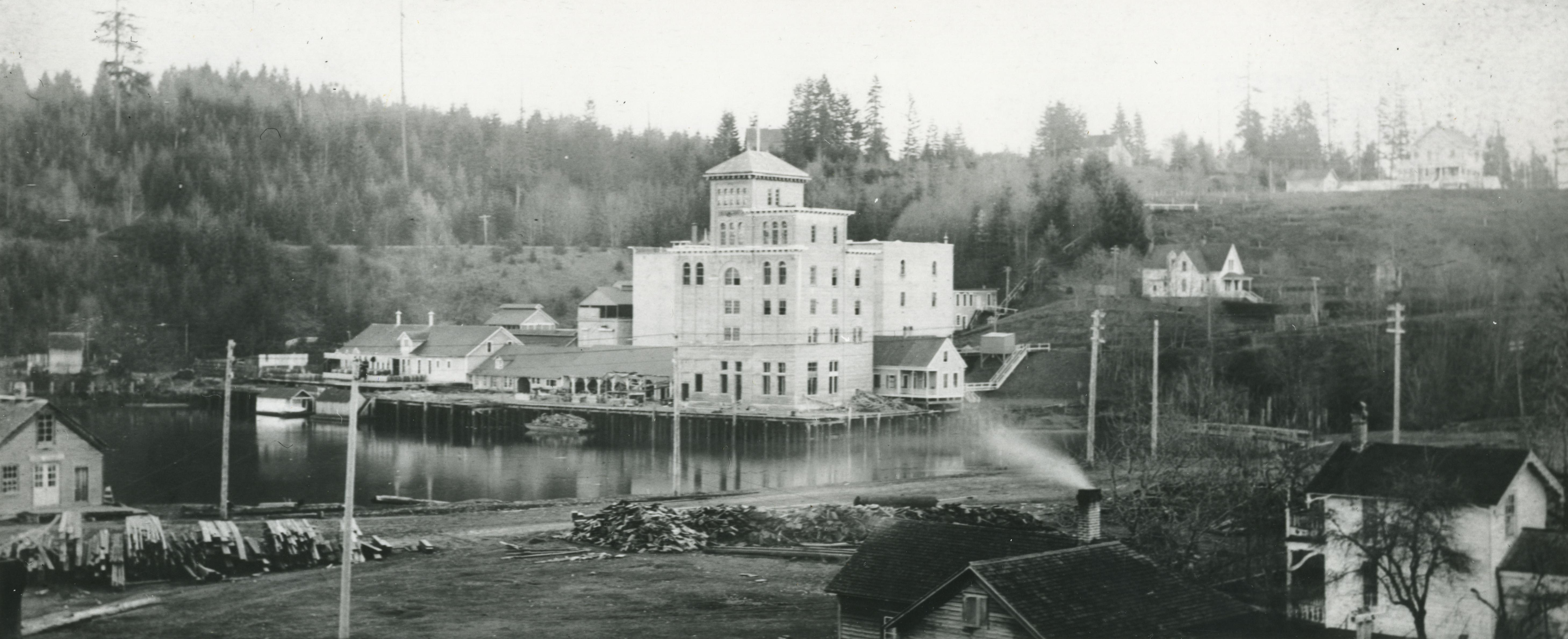
Tumwater and Olympia Brewery from UW Library:

Here is how the road looks when you overlay (from this map from the Washington Digital Archives) it with modern Tumwater.

And, just because I used Google Earth, here it is at a lower angle.

The main difference to me is obviously Interstate 5’s impact, cutting directly through the landscape. Other than that, its striking how much fill has been added. The center of the old waterway is now fill, for instance.

If we call the basketball rivalry, the Capital Cup, what should we call a local soccer competition?

Since Brandon Rosage is now doing a sports podcast locally, made me think about how I’ve been meaning to write more about local sports.

There is at least an exhibition competition between Evergreen State and Saint Martins, but there is no similar series between the local Olympia-area soccer teams. So, for the time being, I’m going to start keeping a ranking of the local college soccer teams.

The basic ranking will the point-per-game for league games between the men and women teams of both Evergreen and Saint Martins and the mens team at South Puget Sound (no womens teams). I know this is a bit late, since the college soccer schedule ended months ago, but I’m going to keep closer track next year, on a week to week basis.

Here’s this year winner of the cup to be named later, the Saint Martins women, who earned just better than a tie per league game, with the Evergreen Men coming in second.

Games Pts PPG
SMW 14 21 1.5
EM 14 14 1
SMM 10 6 0.6
EW 9 0 0
SPSCC 13 0 0

So, what should we name it?

And, if you were wondering, this is my first post about what I want to call “real sport,” which in this case isn’t the MLS Sounders, but local college soccer teams that we all should pay closer attention to. And, maybe this ranking is a way of putting a better focus on the local college scene.

Just realized I tried something like this on Olyblog a few years ago and I called the cup the “Tolmie Cup,” after a Brit who hung around here a hundred years or so ago. Maybe that’s still a good idea, but I’m willing to take suggestions.

Approaching Tumwater’s past fate

Images from the City of Tumwater:

Being in Steilacoom for a few hours yesterday got me thinking about that old saw about Tumwater: that even though Tumwater city fathers invited I-5 into town to roll right over the old Tumwater downtown, it was a short sighted decision and ending up “killing the town.”

Steilacoom struck me as what Tumwater could have ended up like if I-5 had gone around the old town. Slow, a few old commercial buildings tucked neatly into a mostly residential town. Probably smaller than it is now, depending of course on how close I-5 got to town. Probably what saved what we now know as Steilacoom is that Pierce County gave the outskirts of town to the Army to build Fort Lewis.

Anyway, first off, I took a look at what the most basic impact I-5 had on Tumwater. In short, did the city father’s gamble in the 1950s, to raze the old Deschutes-side downtown for an interstate, work out?

So, here’s a spreadsheet that puts together two basic measures, structures (which I stumbled upon months ago) and population.

There was an early surge in structures from Tumwater after the highway went in, but Olympia quickly took the lead.

In terms of population, there also was a surge, and Tumwater is still leading in growth, but their lead is shrinking.

So, in short, yes the gamble worked. By the raw numbers, I-5 coming through certainly had an impact and seemingly surged Tumwaters growth (and in my opinion) made it the town it is today. But, that surge is subsiding, and I’d even venture to say that along with Lacey being created out of nearly nothing, Tumwater’s post I-5 growth advantage is now gone, and all the communities are on the same playing field.

Green River Pop in Steilacoom

Bair Bistro, via flickr, by Suburban Times

Green River Pop has been around for years, and its one of those kid memories I have that I try to make my way back to. Usually I can find it in a random gas station, but for the past ten years, its been harder and harder to find.

Even harder (well impossible) has been the mythical hand mixed Green River pop, which I’ve hear of, but never actually seen in the wild. Until today at lunch when I drug my family up to Steilacoom to the Bair Bistro (former Bair Drug) where they’ve been serving hand mixed Green River pop since Christmas:

There’s an old/new item on the menu at the Bair Bistro in Steilacoom.

It’s called “Green River” (not to be confused with the coffee-colored liquid that meanders through Auburn), and the refreshing, green beverage conjures up a bit of nostalgia for those who remember “the good old days.”

A few days before Christmas, a handful of regular customers had an opportunity to taste-test this old-fashioned liquid while Bistro proprietor Sarah Cannon experimented with the recipe to replicate the perfect “Green River.”

After several patrons had sampled the mixture, Jane Bair Light, granddaughter of Bair Store founder, W. L. Bair, added her straw into the sample blend…sipped deeply, paused …and pronounced, “no, it needs a bit more syrup.”

The syrup/soda proportions, Cannon vowed, will be perfected by the time patrons flock to the Steilacoom Historical Museum’s “Living Museum” to order the renowned soda fountain drink.

Here is my photographic evidence. One with the carbonated water and syrup before mixing.

And, one immediately after.

When we arrived, we were informed that they were out of C02, so my Green River pop had to be mixed with regular soda water. My overall impression is that in terms of taste its very close to what Green River tastes like out of a bottle, possibly just a little less sugary.

And, of course Green River (soft drink) has a wikipedia entry.

Is there any place in Olympia that does hand mixed pop?

What the hell is wrong with Nikki McClure’s “Speedy the Geoduck?”

Evergreen is looking for a new Geoduck logo. Nothing wrong with that, but what’s wrong with the great logo they’ve already used? And, from what I remember, its designed by Evergreen Grad and all around great Olympian Nikki McClure.

I remember talking to then athletic director Dave Weber when they (the athletic department) rolled out the new geoduck, which must have been maybe 10 years ago or so. He said it was drawn by McClure and that it would be a logo for the sports teams. I assume since then, its use has faded away, since its almost impossible to find online, especially on the Evergreen website.

Great logo though, they should really consider resurrecting it.

Well duh update: I couldn’t remember where I’d seen the logo recently, and it turns out it was on an Evergreen website, at the bookstore. They’re already using on hats!

« Older posts Newer posts »

© 2026 Olympia Time

Theme by Anders NorenUp ↑