When I wrote last week about Tono, I was thinking about all the non-Tono ghost towns we don’t think about, the ones lost to inaccessibility, or those that never managed to keep their ruins standing. Lewis County has a dozen or so of these across the timber and coal industries (Hurn, Mendota, and others): towns that simply ran out of reason to be.
Tono taught us that history survives the physical. It was a place erased by corporate action and resource exhaustion, its memory surviving in old maps and the stubborn curiosity of GIS layers. I argued that the built environment is not the memory. The detailed records (what we can piece together) are the memory.
But what I’ve always wondered about is a ghost town lost in plain sight. What if Puget City, north of Lacey, had grown during the resource era, died, been forgotten, and then completely paved over in the name of urban progress?
While not a perfect example of growth, decline, and erasure by suburbia, the East Capitol Campus in Olympia is a lost, ghosted city. And it explains a lot about what went wrong in Olympia’s growth after the 1950s.
The Lost City
Tono was a company town that faded out. This Olympia neighborhood was healthy, dense, and killed.
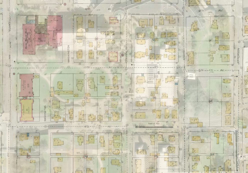
The destruction spanned 18 blocks, bounded by Capitol Way on the west, Jefferson on the east, 11th on the north, and Maple Park on the south. This is now the collection of state office buildings across from the Capitol Campus proper. The neighborhood included a rich tapestry of density that Olympia today desperately tries to rebuild: no fewer than six apartment buildings (two with over 30 units), duplexes, the Girl Scouts clubhouse, and at least one store.
It was also the second location of William Winlock Miller (aka Olympia) High School. The state’s appetite for land here was so great that this was the second time the expanded Capitol Campus displaced Olympia High School. The original Olympia HS was on Water Street, a location that no longer exists but was roughly between the diagonal drive and the big old oak by the Sunken Gardens.
The catalyst for this violence was not a coal vein running out, but a court case: State ex rel. Lemon v. Langlie (1954). The ruling, which forced state executive offices to maintain their main offices in Olympia, solidified the city as the seat of government, and in doing so, condemned this residential district.
The Bureaucratic Weapon
The killing wasn’t a sudden demolition; it was a long, cold administrative death. The original buildings: Highway Licensing (1961), Employment Security (1961), and Archives (1964) came first. But the real destruction happened in the 1970s, after the city eliminated the historic cross-streets by vacating rights-of-way in the mid-1960s.
This is the big deal. You can build around a neighborhood; you can’t sustain a community once its streets have been wiped off the map. Ironically, the original right-of-way for 12th Avenue still exists, running straight through the 1991 Natural Resources Building. The built environment was literally erased.
In the 1960s, the state set out to take over 75 properties. The struggle put a human face on the process through the saga of Roy H. Bergh, 77, and his wife Leila, 72. The Berghs resisted the state’s efforts for about 13 years, leading to a prolonged legal battle involving condemnation and, ultimately, their eviction and jailing in 1973. They felt the state had “stolen” their property. The land they went to jail for is now part of the northern flank of the Natural Resources Building, at what used to be the corner of 12th and Franklin.
This ideological erasure was compounded by massive infrastructure projects that completed the destruction. Interstate 5 was constructed along the back edge of the neighborhood, and Plum Street was expanded via Henderson Boulevard into Southeast Olympia. We can’t overstate how radically this shifted access, suddenly, getting into that end of town by car mattered more than moving through the old city grid. While citizens voted to save Watershed Park in 1955, just five years later we were putting a road through it on the way to the third Olympia (William Winlock Miller) High School.
The Brutalist Betrayal
The final product, designed in the 1970s, was a monument to the state’s ambitions, and it failed to provide value to Olympia.
What we have now was designed in the Brutalist tradition, characterized by austere, monolithic concrete forms and monumental scale. This architecture prioritizes power and control over human-scale interaction and community. The new East Campus, most notably the manically vaguely named “Office Building 2” (1975) and the massive underground garage (1975), which famously began leaking almost immediately, was a policy failure if the goal was to create a human-scaled, useful addition to the city.
The creation of the East Campus shifted the center of civic life (the high school) to a contested border with another city (Tumwater) and promoted the development of car-centric districts, reinforced by millions of dollars in bonds for parking facilities.
The result is a landscape largely divorced from human use or utility: massive, useless expanses of lawn that no one occupies; a long stretch of Capitol Way with no sidewalk on its east side; and the bizarre arrangement of walkways threading around the buildings.
This is a space most often transited rather than enjoyed. Protests happen across the street at the Legislative Building. Community events take place downtown or around Capitol Lake. This is a broad civic space that no one uses, or even thinks about, unless they’re forced to inconveniently walk through it because they parked somewhere else.
Around OB2 and the Natural Resources Building, paths curve toward nowhere. A grand staircase ends in grass. Rounded walkways circle a vestigial OB2 entrance along Jefferson.

This area was supposed to be the beginning of “Ceremonial Drive,” a road that would have snaked around the buildings near where the Natural Resources Building now stands and where the old courthouse (now Capitol Court) remains.
What did we lose for that odd arrangement of nothing on Jefferson? Five houses and four duplex units. The East Campus is the grandly designed version of a exclusively zoned single family neighborhood. Nothing in walking distance, so if you leave your house on foot (or accidentally walk through East Campus) it is only for the act of walking, not going anywhere there.
Tono taught me that losing physical structures isn’t the same as losing history, you can reconstruct the past from afar. But the East Campus teaches something else entirely: some change is an ideological act of violence against history.
I’m not arguing the neighborhood should have been frozen in time, or that the state shouldn’t have expanded. But this neighborhood was never allowed to evolve. Today, state offices are at least expected to weave into neighborhoods, imperfect as that system is. The East Campus, by contrast, was simply killed, wiped off the face of the city.
And I point this out without irony as residents of the South Capitol Neighborhood fight a pitched battle against legislative-centric businesses expanding into residential homes, that they were the original target of campus planners’ expansionist ambitions.

Before heading east, the proposal envisioned a southern expansion of the campus. More than 20 acres of the South Capitol neighborhood would have been razed and replaced with new government buildings, along with a rounded road system that would have largely replaced the existing street grid.
But we all know how this ended. The campus expanded east, not south. Instead of annexing a more affluent neighborhood, the state razed a more middle-class community on its eastern flank.
You can’t stand today in the middle of this vast, empty expanse and pretend the past is intact. But because the architecture and landscaping are so empty and silent, the history still exists, in the sad story of the Berghs, the memories of the high schoolers, and the ghosted street grid beneath our feet. The built environment is not the memory. And thank goodness, because in this case, the builders made sure the built environment was a lie.


So much credit for this post and line of thinking to Brian Hovis, who years ago spent a great deal of time overlaying old Sanborn maps onto modern Olympia and then gifting that work to us: https://olympiahistory.org/the-sanborn-overlays/
This struck close to me too. My great grandparents lived at 1074 Washington around the time he died in 1927. Winfield Scott McCool was an Engineer who had come to the area 30 years before.
That address best I can tell is on the edge of the condemned properties but no matter the house does not exist today.
Thank You for digging around in lost places. People are so oblivious to how many of them there are.
Nice history. It’s saddening that the capitol campus is built partly on top of a lower income neighborhood. Also, fascinating to read about the origin of the sidewalk-less stretch along the east side of Capitol Way. It is not going to be remedied by any of the proposed corridor improvements, as far as I could tell from the open house. I’ll have to reflect on this history the next time I walk through the East Campus, which is really too bad; It’s my second favorite directionally-named part of the Capitol Campus.